Drone 3D Topography & Contour Mapping for Construction
Drone 3D Topography in Pakistan Survey Your Entire Site in Hours, Not Weeks
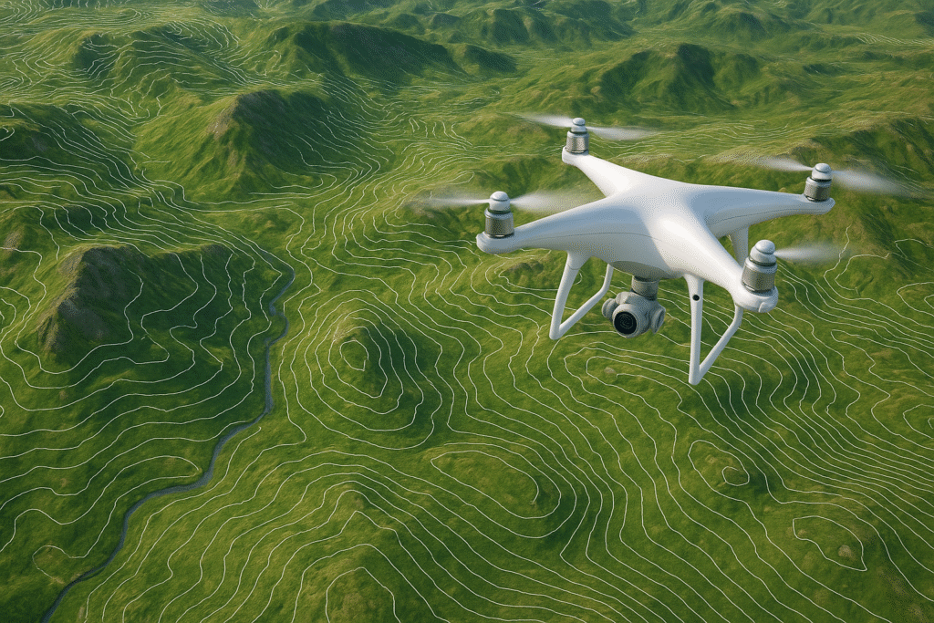
A land survey that used to take a field crew two weeks now takes a single drone flight and 48 hours of processing. That is not an exaggeration. It is what happens when you replace total stations and manual traverse with a DJI Mavic 3 Enterprise RTK flying a pre-programmed mission at 120 meters.
We provide drone 3D topography surveys across Pakistan for construction, real estate, infrastructure, agriculture, and mining projects. You get centimeter-level accuracy, contour mapping, Digital Elevation Models, orthomosaics, and 3D point clouds. Delivered as files your engineers and architects can open on day one.
No more waiting on traditional field crews. No more missing data from areas too steep or too large to walk.
- Drone 3D topography surveys covering 2 square kilometers per flight
- 1cm horizontal and 1.5cm vertical accuracy using RTK positioning
- Site planning drone services for construction, real estate, and infrastructure teams
- DJI Mavic 3 Pro survey platform with 20MP mechanical shutter camera
- Outputs include DEM, DSM, orthomosaic, point cloud, and contour maps
- Contour mapping in Pakistan delivered at 0.5m and 1m intervals
- Free project scoping and flight plan before any mobilization fee

Get a free quote
Others services
- Water Boring Services in Karachi
- Boring Water Rates 2026
- Geological Mapping & Subsurface Data Services
- Boring Water Pumps, Motors & Pipe Price List 2026
- Industrial & Residential RO Plant Installation
- Solar Powered Tube Well Systems & Installation
- Water Boring Machines & Drilling Equipment (Buy/Hire)
- Hydrogeological & Hydrological Investigation Services
- Geotechnical Investigation & Soil Testing for High-Rises
Our process
What Drone 3D Topography Actually Delivers
Traditional surveys give you linework on paper. A drone topographic survey gives you an orthophoto, a contour map, a digital terrain model, and a dense point cloud. All from a single flight.
01.
How the Survey Works, Start to Finish
The flight plan is designed in the office before we reach the site. Survey area, flight altitude, image overlap, and ground control point locations are all set in advance. On site, we set up Ground Control Points (GCPs) across the survey area, surveyed with RTK GPS to confirm their exact coordinates. The DJI Mavic 3 Enterprise then flies its pre-programmed mission, capturing several hundred to several thousand overlapping images depending on site size. Those images, combined with the RTK positioning data, go through photogrammetry processing software such as Pix4D or DJI Terra. What comes out the other end is a dense point cloud with millions of measured 3D coordinates, a digital terrain model of the bare ground, a digital surface model including all features above ground, a georeferenced orthomosaic photograph accurate to within 2 to 3 centimeters, and contour lines generated at your specified interval.
02.
The Outputs and What They Are Used For
The orthomosaic is a geometrically corrected aerial photograph of the entire site where every pixel represents a measurable location on the ground. Architects use it as a site base map. Developers use it in planning applications. Engineers use it to verify existing conditions against design drawings.
The Digital Terrain Model shows the bare earth surface without buildings or vegetation, which is what drainage engineers, road designers, and civil contractors need for grading and cut-and-fill calculations.
Contour mapping in Pakistan, generated from the DTM, shows elevation change lines across the site at intervals you specify. At 0.5 meter contour intervals, the terrain detail is sufficient for detailed building pad design, road layout, and water retention modeling.
The point cloud is a three-dimensional dataset of millions of measured points. It can be sliced at any location to produce cross-sections and profiles, used to calculate earthwork volumes, and imported directly into AutoCAD Civil 3D, ArcGIS, or any other engineering platform your team uses.
03.
Service Tiers for Different Project Scales
The Small Site Package covers areas up to 5 hectares in a single flight session. Suited to individual plots, building sites, and small agricultural parcels. Deliverables include full orthomosaic, DTM, DSM, and contour map at your specified interval. Turnaround in 2 to 3 working days.
The Medium Site Package covers 5 to 50 hectares across multiple flight sessions. Suited to housing developments, roads, industrial sites, and large agricultural holdings. Deliverables include all standard outputs plus volumetric calculations and CAD-compatible files. Turnaround in 4 to 6 working days.
The Large Area Package covers 50 hectares and above, requiring multi-day fieldwork and extended processing. Suited to township master planning, river corridor studies, mining concessions, and large infrastructure corridors. Fully custom-scoped. Includes a written flight plan and survey methodology statement for regulatory or client approval.
All packages include raw data files and a final technical report documenting survey methodology, accuracy verification, and coordinate reference system used.
Why Choose Us
Why Pakistan's Construction and Development Sector Chooses Our Drone Survey Services
There are drone operators with cameras. There are drone surveyors with RTK, proper ground control, calibrated processing workflows, and technical deliverables that hold up under engineering review. These are not the same thing.
Survey-Grade Accuracy, Not Just Aerial Photography
The DJI Mavic 3 Pro survey configuration we operate includes the RTK module that brings horizontal accuracy to 1cm and vertical accuracy to 1.5cm. That means the contour lines on your map represent actual ground elevations to within centimeters, not the broad approximations you get from a consumer drone photographing the site for visual reference. Every survey we deliver includes an accuracy report with Root Mean Square Error values calculated from independent check points, so your engineers can confirm the data quality before they design it.
Outputs in Formats Your Team Already Uses
Point clouds in LAS format for import into AutoCAD, Civil 3D, and Bentley MicroStation. DEM and DSM rasters in GeoTIFF for ArcGIS and QGIS. Contour lines in DXF or SHP. Orthomosaics in georeferenced GeoTIFF. We ask what software your design team uses before we process, and we deliver in the formats that open without conversion. No translator fees. No compatibility errors discovered at 11pm before a client presentation.

Written Scope, Fixed Deliverables, No Surprises
We provide a written survey specification before any fieldwork begins. It states the survey area boundary, flight altitude, planned GCP layout, coordinate reference system, output formats, contour interval, and delivery date. That document is the contract. If site conditions during the flight require a scope adjustment, we communicate it before we process, not when we send the invoice.
Standard delivery is 48 to 72 hours after fieldwork completion for sites under 20 hectares. We can prioritize a 24-hour turnaround when project schedules require it. For large area surveys, we provide a phased delivery schedule so your team can start working on completed sections while data from remaining areas is still being processed.
Excellence skills & Quality work
Our commitment to precision drives every project we undertake. We combine technical mastery with a rigorous attention to detail, ensuring that every borehole, survey, and engineering solution meets the highest industry standards. By prioritizing safety and structural integrity, we transform complex geological challenges into seamless, high-performing assets for our clients.
For further inquiries call
0308-7005333
Or email us at info@shdrillings.com. We will get back to you within 24 hours